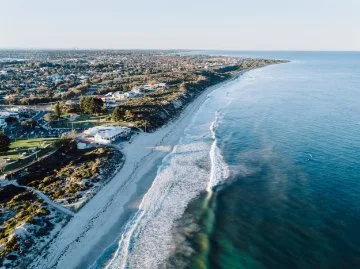
The City of Joondalup is home to 17km of incredible coastline between Marmion and Burns Beach, most of which is adjacent to the Marmion Marine Park. The coastline is varied over this area, and can include rocky limestone cliffs, headlands, nearshore reefs, sandy beaches, pocket sandy beaches and dune systems.
The City's coastline holds significant value for both residents and visitors. In response to potential impacts of climate change, such as erosion and storm surges, the City has initiated efforts to better understand these risks.
Coastal hazards

Definition
Coastal hazards include:
- Coastal erosion: where sediments and sand from beaches and dunes are broken down and moved away by wind, waves and currents. Erosion can reduce the width of a sandy beach and reduce sand dunes.
- Inundation: temporary flooding of coastal areas.
Coastal inundation is not considered a high risk for the City’s coastline and City assets.
There are several areas along the City’s coastline which are already affected by coastal erosion. Coastal erosion risks are likely to worsen into the future due to climate change impacts.
Coastal hazard assessment
A coastal hazard assessment conducted in 2015 focused on the City's coastline, aiming to pinpoint areas susceptible to erosion over the next century. The assessment revealed in the short term, sandy beaches and related infrastructure like access ways and dune fencing may face vulnerability.
Over the long term (beyond 50 years), additional infrastructure such as car parks, select City-owned buildings along coastal foreshore areas, and some private properties could potentially be at risk from severe storm erosion.
Coastal vulnerability notification list
Stay informed about coastal hazard updates and actively participate in shaping the future of the City of Joondalup's coastline.
Sign up for the Coastal Vulnerability Stakeholder Notification list to receive email alerts whenever new coastal hazard information is released and opportunities to contribute to future planning arise.
Caring for our coastline
Coastal monitoring
The City has been undertaking a Coastal Monitoring Program since 2015-16 which includes the following elements:
- Beach and hydrographic surveys conducted every two years from behind the primary dune to several hundred metres offshore. A total of 22 profiles are completed over approximately 15km.
- Inspections and photographic monitoring of the beaches within the study area every six months.
- Mapping of the shoreline from aerial photographs taken every year.
- Assessment of the change and impact from any coastal management activities, such as sand bypassing.
- Analysis of the monitoring surveys by experienced and professional coastal engineers, identifying areas of accretion or erosion.
- A report on the monitoring results and analysis each year, highlighting notable variations in shoreline movements.
The Joondalup Coastal Monitoring 2023-24 Data Report provides the results of the 2023-24 Coastal Monitoring Program and analysis of shoreline change since the baseline year of 2015-16. The Coastal Monitoring Program operates on a two-year schedule with a full comparative analysis and report provided every second year and an annual report without survey comparisons in the intervening years. A full report is provided in 2023-24 and is available below.
Coastal hazard map
The coastal hazard map below show areas that have been identified as potentially subject to coastal hazard risk within a 100-year planning timeframe.
